Choconut Creek Restoration Design and
Permitting
Executive Summary
Choconut Creek, a

The following tasks will be achieved by completion of
this project.
Construction Ready Design –1.5 Miles of stream channel restoration will be designed using natural channel design techniques. Detailed topographic/hydrograph survey will be completed on each of the four design reaches. The survey results will be presented in detailed 3-dimensional drawings for geomorphic analysis, design, and construction. The design will be completed using natural stream design and accepted fluvial geomorphic principles. Erosion and Sedimentation Plans and riparian vegetation planting plans will be produced as part of the design work.
Permitting - All permit applications and
the required supporting documentation will be prepared and submitted to the
required agencies for approval.
Operation and Maintenance – Partnerships for an Operation and Maintenance Agreement will be formalized. Landowner agreements for proper maintenance and protection of the restoration work will be drafted and implemented.
Statement of Need and Justification of Funding
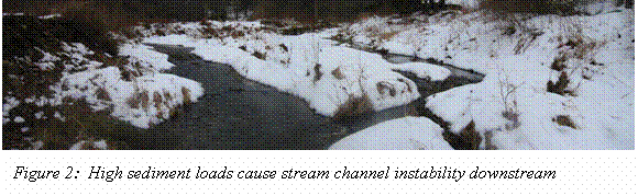
Choconut Creek is producing
large sediment loads due to severe channel instability. The stream channel is entrenched in many
locations and highly unstable reaches cause significant property damage. Channel instability is threatening homes,
roads, and utilities while introducing thousands of cubic yards of sediment per
year to the stream channel. Sediment
produced from this 30.5 square-mile drainage area reduces channel stability
downstream. This sediment enters the
A strategic restoration plan for Choconut Creek is currently in draft form. From the assessment data collected as part of the strategic plan, areas of unstable stream channel and bank failure were identified (see attached maps). Large gravel bars are migrating through the stream system. This is evident from the bed forms in the stream channel and the prevalence of mid-channel bar deposits along the stream. If allowed to continue to migrate downstream the sediment load will further destabilize downstream reaches of Choconut Creek and increase flood damage as the channel bed elevation increases.
As part of the recently initiated watershed
assessment, stream bank and channel stability were evaluated from St. Josephs
downstream to the NY State line.
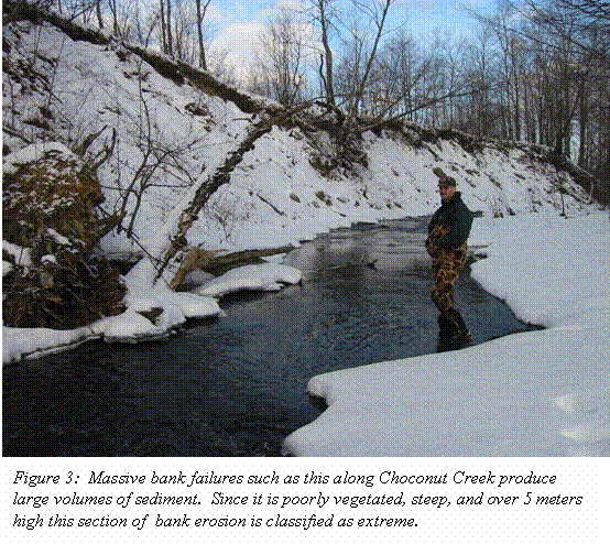
Over 9,000 feet of unstable stream bank were located through
this survey. These eroding banks
introduce an estimated 50,000 tons per year of sediment to the system. Much of this sediment is fine-grained soil
particles that can severely impact aquatic life in Choconut Creek and further
downstream in the
 Gravel
bars were located in 29 stream reaches indicating excess sediment loads in the
stream system. Gravel bar deposits split
the stream channel and cause additional stream channel instability and bank
erosion. The bar deposits are indicators
of excess sediment that exceeds the stream’s sediment transport capacity. These conditions upstream from the stream
reaches currently targeted for restoration have the potential to reduce the
effectiveness of the current restoration project located immediately downstream
of the proposed project area.
Gravel
bars were located in 29 stream reaches indicating excess sediment loads in the
stream system. Gravel bar deposits split
the stream channel and cause additional stream channel instability and bank
erosion. The bar deposits are indicators
of excess sediment that exceeds the stream’s sediment transport capacity. These conditions upstream from the stream
reaches currently targeted for restoration have the potential to reduce the
effectiveness of the current restoration project located immediately downstream
of the proposed project area.
Bank Erosion Summary
|
Severity |
Count |
Total Length (Meters) |
|
Extreme |
6 |
311 |
|
Severe |
22 |
688 |
|
Moderate |
55 |
1369 |
|
Mild |
32 |
1370 |
 In total over 3,700 meters (2.3 miles) of bank erosion and
channel instability threatens property and aquatic life along Choconut
Creek.
In total over 3,700 meters (2.3 miles) of bank erosion and
channel instability threatens property and aquatic life along Choconut
Creek.
In addition to improving aquatic habitat, reducing non-point
source sediment inputs, and protecting property this project will continue and
enhance community involvement in the watershed.
The
Strong community support and strategic partnerships provide
the Choconut Creek Watershed Association the solid support necessary for
success of a project on this scale. Signed
landowner agreements for this reach of stream are attached to this
application.
Goals and Objectives
The primary goal of this project is to complete a detailed construction-ready design based on solid strategic planning that will provide a large reduction in sediment output from the Choconut Creek Watershed and protect downstream restoration efforts. Areas where infrastructure and property are threatened by rapid stream channel migration will be reduced. Both aquatic and riparian ecosystems will benefit from the completion of this project.
- Complete
design of 1.5 miles of natural channel restoration, collect detailed
survey data within the reaches and interconnecting reaches to provide a
framework for the design.
The goals of the watershed association advocate learning about the systematic causes of channel instability and habitat impairment to provide solutions at the watershed scale. Completion of this design will allow the watershed association to implement restoration efforts that avoid “band-aid” fixes and focus on a systems based approach to stream restoration with each restoration project being a key piece of the entire watershed system.
- Complete
addendum to watershed wide permit and all supporting documentation for the
restoration reaches.
The watershed wide permit submitted
in 2002 provides the baseline information for the watershed utilizing the
restoration plan. These projects as
components of the strategic plan can be submitted as addendums to the permit
streamlining the processes.
3. Develop
an innovative Operation and Maintenance Agreement for protection of the
restoration project.
It is important the integrity of restoration work completed by the watershed association be protected over time. To this end, the watershed association and other partners will work with local municipalities to develop ordinances protecting stream restoration work. Additionally an Operation and Maintenance Program will be developed for implementation with construction of the designed restoration reaches. Local and regional partners will be solicited for commitments to the Operation and Maintenance Agreement. An agreement for landowner consent and maintenance guidelines will be drafted for use with restoration construction.
Partnerships
The
Choconut Creek Watershed Association is partnered with the following
organizations to complete this project: Susquehanna County Conservation
District,
Work Plan
Fall 2002 – Winter 2003
To provide the data required to complete the natural channel design, aerial topography and ground-based detailed channel hydrography will be completed for the restoration reaches. Necessary survey data to link the intervening reaches to the overall design will be collected.
Working drawings will be produced using Computer Aided Drawing software. Details including longitudinal profiles, channel cross-sections at intervals through the design reaches, and overall plan views will be generated.
Detailed geomorphic design data including multiple particle size distributions, hydrology/hydraulics data, and bar sediment sieving will be completed. Locations of grade control and bridge crossing dimensions will be incorporated into the dataset. Design constraints will be identified.
Winter 2003
Preliminary design will begin in Winter 2003. Using reference reach data, if available, regional curve data, and regime equations the proper channel alignment will be determined. This alignment will then be evaluated using aerial photography and the existing survey data to determine if there are problem areas.
Once the preliminary alignment is established, meetings will be held with landowners to review the channel alignment and determine if there are any landowner issues.
Upon reaching a satisfactory alignment in conjunction with the landowners, the design can proceed.
Spring 2003 – Winter 2004
Detailed design work will be completed for each of the restoration reaches. Natural channel design techniques will be applied to the final construction-ready design for the four restoration reaches. Proper channel dimensions in plan form and cross-sectional form will be detailed on engineering plan sheets. Where necessary, rock instream structures and other stabilization measures will be specified to ensure channel stability.
Design reviews with the watershed association, Susquehanna
County Conservation District,
A detailed Erosion and Sedimentation Prevention plan will be developed as a component of the design phase. The Susquehanna County Conservation District will be very involved in erosion and sedimentation prevention practices to be designed for the project.
A maintenance plan will be developed for the restoration reaches. This plan will target potential partners and beneficiaries of the restoration effort.
Fall 2003 – Summer 2004
Permit applications and all required supporting documentation will be prepared and submitted to the proper agencies.
An amendment to a watershed-wide permit applied for in 2002 will be submitted to PADEP and USACOE for technical review.
Operation,
Maintenance and Replacement Tasks and Responsibilities
- Develop
Operation and Maintenance (O&M) Criteria (LDG)
Guidelines for operation and maintenance of the restored areas of stream channel will be developed for use in the O&M agreement. Specific criteria will be provided to guide when maintenance is required and how is should be completed.
- Draft
landowner O&M agreement (LDG, SCCD, CCWA)
A detailed landowner agreement will be developed for use with constructed restoration projects. This agreement will outline allowable streamside maintenance practices adjacent to the restoration area. The agreement will prohibit activities that have the potential to reduce the effectiveness of the restoration work.
- Recruit
O&M partners, secure commitments.
(CCWA)
The local townships and the county are likely partners for the O&M agreement. Additional partners and funding sources will be sought through this process.
Project Deliverables
(Responsible Party in Parenthesis)
- Educational meeting as a project kickoff to present the project scope and information about the assessment and restoration process to the public. (LDG & CCWA)
- Comprehensive natural channel design, planting plan, stabilization measures, and specifications 1.5 miles total stream channel length. (LDG)
- Complete existing condition plans and proposed condition plans ready to complete construction. (LDG)
- Joint Permit Application (LDG)
- Operation and Maintenance Plan (CCWA & LDG)
6. Riparian Revegetation Plan (LDG)
- Post design public meeting (LDG, CCWA)
Measurable Environmental Results/Benefits
- Non-point source sediment loads from the Choconut Creek Watershed will be significantly reduced upon construction of this design.
- Natural channel design and permitting will be completed for 1.5 miles of stream channel. Implementation of this design will reduce bank erosion and sediment output from the 1.5 mile reach.
- The quality of a downstream 3,600-foot restoration project currently in progress will be improved by reduced sediment loads from this project.
- Stream habitat for macroinvertebrates and fish will be improved not only in the restoration reaches, but in reaches downstream from the project.
- Embeddedness will be reduced as a result of increased channel stability and decreased sediment discharge from the headwaters.
- Downstream reaches of Choconut Creek that flood frequently due to reduced channel capacity and increased sediment loads will benefit from sediment reduction. Downstream channel migration will be reduced as sediment loads decline.
- Threats to infrastructure and personal property in the Choconut Creek Watershed will be reduced.
Disposition of Equipment
All equipment purchased with funds from this grant will be converted to the Choconut Creek Watershed Association for use in the further restoration and preservation work.